


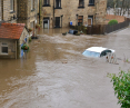


Flooding in areas of southwestern Poland had to happen? Klodzko, Nysa, Jelenia Gora, Glucholazy other towns lost to the elements. Heavy rainfall resulted in severe flooding. The flood control infrastructure did not hold up. The levees failed in several places, the retention reservoir in Paczków burst, and the culvert between the Topola and Kozielno reservoirs was destroyed. Could we have been better prepared for this?
I am of the opinion that we do not have a good relationship with water. We go to extremes - either we have a drought or a flood. Ba, now we even have 2 in 1. The east of our country is in drought, the southwest is flooded. Today, the headlines mainly show flooded towns, fortifications, cleanup after the flood wave. However, the water problem is much wider, as it does not only affect Lower Silesia and Opole.

MGW meteo map - hydro warnings
After the flood of the millennium in 1997, it would seem that we would no longer allow such a tragedy, that we would do everything we could to prevent rivers from flooding again. And yet it happened. Klodzko, which still bore the discoloration on the walls of many houses from the previous level on the plaster, has to fight again.
It's not that this water surprised us very much. Rather, everyone hoped that somehow it would go away. After all, a lot has changed after the great flood of the late 1990s. The floods of 1997, 1998, 2006 and 2010 mainly affected areas of the Upper Oder River Basin, the Klodzko Basin and the Upper Vistula River Basin, revealing deficiencies in the flood protection system of these regions, including the city of Wroclaw. This prompted the Polish government to take steps to develop and implement flood protection programs[1]. These initiatives introduced a number of investments and international agreements to improve the safety of at-risk areas.
lots of action and money
In response to these threats, a loan agreement was signed between the Polish government and the International Bank for Reconstruction and Development on May 11, 2007[2]. Funds from the World Bank, the Development Bank of the Council of Europe, as well as EU and domestic funds, were allocated for infrastructure upgrades and the construction of new hydrotechnical facilities. Although inspections of project implementation by the Supreme Audit Office (SCA) confirmed that the funds were spent in accordance with the objectives set forth in the loan agreements, due todelays in project implementation, the original cost estimate of 505 million euros was increased to 727.23 million euros, and the project's completion was postponed from 2014 to the end of 2020.
There was a vision to implement the Oder River Basin Flood Protection Project (OPDO). It was to be a comprehensive approach to the issue of flood protection in the Oder River Basin, combining engineering activities with education and risk management. Four main components were pursued: construction of the Racibórz Reservoir, modernization of the Wroclaw Water Junction, improved monitoring and surveillance of flood risks, and project management. Each of these components was aimed at increasing flood protection for residents along the Oder River from Raciborz to Wroclaw.
The POPDOW Project (Flood Protection of the Oder and Vistula River Basins) was to have a slightly broader effect, assuming a much wider scope of activities, covering not only the Oder River basin, but also the upper Vistula. The total cost of the Project was set in 2015 at approx. 1,202 million euros[3].
walls remember
However, let's return to Klodzko. The losses suffered by the city in 1997 were estimated at nearly PLN 92 million[4]. The new Klodzko Basin protection project included the construction of four key retention reservoirs to protect the population and property from subsequent floods. Four were built: Boboszow (capacity 1.4 millionm3), Roztoki Bystrzyckie (capacity 2.7 millionm3), Szalejow Górny (capacity 10.67 millionm3) and Krosnowice (capacity 1.9 millionm3). All for more than 976.2 million zlotys. You may be familiar with this topic. After all, somewhere the echoes of the 2019 events are piercing through. If you type the topic of Kłodzko reservoirs into a search engine, you'll find that you'll be inundated with a wave of different news, mainly that in response to protests by the region's residents, the government has halted some projects for more reservoirs[5]. The thing is, the protests were mainly about the analysis of the documents made available to the Polish Waters, which planned to build more reservoirs. Unsurprisingly, residents who disagreed with the construction (depending on the variant) of 16 or 9 reservoirs and the displacement of 2,500 people in the worst-case scenario reacted nervously[6], immediately rioting. Polish Waters quickly issued a statement saying, "There are no new reservoirs being built in the Klodzko region in any of Polish Waters' investment plans."[7] When we see these headlines, of course, it's easiest to judge that it had to be accepted. Except... that's not all.
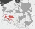
Let's start with the fact that the Floods Directive[8] 2007/60/EC dictates that we create such a document as a preliminary flood risk assessment (WORP). Under the Polish Water Law, the Polish Waterways develop flood hazard maps (MZP) and flood risk maps (MRP), in cooperation with the provincial governors, and maps for marine areas are drawn up by the maritime offices. Approval and publication of the maps are the responsibility of the minister in charge of water management. The purpose of the CMOP is to identify areas at risk of flooding, based on information on hydrography, flood history and potential future risks. However, the CMOP is not used to precisely delineate the extent of these areas, but to identify them initially.
Flood hazard maps (FMPs) and flood risk maps (MRPs) are developed based on the results of the CMOP and form the basis for taking measures to reduce the negative effects of flooding. These maps are updated in planning cycles, covering flood-prone areas, both riverine and marine.

Flood risk map
In the 1st planning cycle (2010-2015), maps were developed for about 14,500 kilometers of land, which were then updated in the 2nd cycle (2016-2021) to include new areas. As you can easily guess, the results of the subsequent analysis will form the basis for determining the scope of the MZP and MRP update in the 3rd planning cycle, and the results of the review are expected to be available in Q3 2024. The update of the flood hazard and flood risk maps for the rivers or river sections identified in the review will take place by December 22, 2025. The results of the map update review will be published in Q3 2024, and the maps themselves will be updated by the end of 2025[9].
As you can see, we now have a much better recognized situation. Ba, we even have better tools, improved communications, emergency response system. For the Kłodzko district, we have a special, dedicated local flood cover system. Wroclaw and other cities in the region have invested billions of zlotys in improving flood control infrastructure. The Wroclaw Water Junction, which in 1997 could safely accommodate 2200 cubic meters per second of water, is now able to pass as much as 3100 cubic meters per second[10]. Many cities and villages are much better protected thanks to these measures. We cannot say that nothing has changed.
level: hard
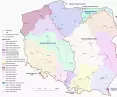
However, while Wroclaw can arm itself with great security, the land of Klodzko is no longer necessarily so. The region is characterized by high flood risk, especially in the basins of the Oder River and its tributaries, such as the Nysa Klodzka, Bystrzyca, Kwisa and Sleza. The flood risk map identifies areas with flood risk. Flood control investments are, of course, provided for in the Flood Risk Management Plan for the Oder River Basin. In 2015, the water status in the region was assessed as bad in 125 surface water bodies, and good in only 4. The watercourses within the Klodzko Land are mountainous in nature. They have hard, rocky or gravel bottoms. Thus, they are swift and rapid - we would say professionally that they are characterized by "high water flow velocities." On top of this, Klodzko is in a basin, with a total of a dozen tributaries flowing in its central part. This layout of the river network determines the nature of flood phenomena in this region - the rapid arrival of water in the watercourses, and thus the formation of flood waves and their accumulation in the estuary sections of rivers[11].To talk about the safety of this region, we need to understand that the outflow of water from the upper Oder River and the catchment area of the Nysa Klodzka River affects the magnitude of the floods, and the floods in the upper and middle Oder are caused by the surges of the Nysa Klodzka and upper Oder. A flood wave can form as a result of surges in the upper Oder River and its tributaries. Flooding can also occur with floods on the Beaver and the Lusatian Neisse.

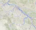
Local Flood Protection System of Klodzko County.
Historical research shows that areas in the lowest part of Klodzko have been subject to major floods dozens of times in the past. "Sorry, this is the climate we have". - one would like to paraphrase. Well, that's right, the climate. I read on a local portal about work on securing the city[12]. The city's 2023 was in the process of caulking the waterfront (simplifying this means creating a permanent wall), which is claimed to protect against flooding. "In the context of the four flood control reservoirs already built above the city, it can be assumed that the water level in the river will not reach such high levels as, for example, during the July 1997 floods." - we read. On the government website, meanwhile, we can read that "increasing the safety of residents, in this particularly flood-prone area, is a priority for the Polish Water Authority." Not long ago, on July 30 of this year, Polish Waters' vice presidents Balcerowicz and Jarząbek visited Klodzko Land. "The flood control reservoirs in Klodzko Land are an example of modern hydrotechnology. All four polders form a modern system," - they said. "The more than 100-year-old reservoirs in Międzygórze and Stronie Slaskie, built in response to the devastating flood of 1897 under the direction of Professor Intze and Dr. Bachmann, could not protect the region from the catastrophic flood that happened even a century later - in 1997." - added the authors of the text[13]. Did the reservoirs work? No. Did they help? They certainly have, to some extent. The 2018 development strategy[14] says that Lower Silesia's water system includes both rivers with the Oder River as the main hydrographic axis. There are numerous reservoirs in the region, including 12 large retention reservoirs, more than 1,700 ponds and about 200 small retention reservoirs. In total, the waters cover 32,605 hectares, or 1.63% of the province's area.
let's give those reservoirs a break
However, we cannot reduce the conversation about flooding to reservoirs alone. After all , even the most modern ones are not able to protect one hundred percent. For this is about the entire economy and a system of interconnected vessels. In the Lower Silesian province, the highest losses in infrastructure in the period 2011-2019 occurred in the Kłodzko and Jelenia Góra districts. The causes of reported losses in these districts were: flooding, floods; strong wind, hurricane; hail; driving rain[15].
2014 - a study is published at the National Geological Institute in fulfillment of the task of the State Geological Survey. The authors write there: "hydrotechnical structures provide safety up to a certain point. Above certain values of water flow, they become a source of danger of a magnitude that exceeds that resulting from river surges alone" [16]. They point out that the situation is very serious in the Lower Silesia region. The upper Oder River is a major source of Oder floods. On Sunday, September 15, the dam on the Morawka River in Stronie Slaskie was destroyed[17]. Water stored in the reservoir flowed out instantly destroying buildings in Stronie Slaskie, the surge moved down the Morawka and Biała Lądecka rivers. On the Nysa Klodzka River (into which the Biała Lądecka flows) in Klodzko, the record water level of 1997 was exceeded.
Looking for solutions for the area. "The results of the study indicate that the Bystrzyca Klodzka area on the Nysa Klodzka River is an area with a very high risk of flood danger. The area should be given special attention by local authorities and flood protection services in the context of activities and investments aimed at reducing the risk of flood risk."[18] But what does this mean? Jan Mencwel suggests that the scale of the flooding in Klodzko is linked to the felling of trees in the Śnieżnik Massif[19]. Sure, trees themselves are not everything, their absence, however, has a significant impact on the speed at which water flows. They can be counted as non-technical flood control measures. "According to a study by Dr. Andrew Affek, the network of artificial tracts and firebreaks in the mountains can contribute to increasing the maximum runoff by several percent. And with such precipitation, this is really a lot." - says Prof. Krzysztof Swierkosz[20].

Map of forest clearing
In the analysis of flood defenses for the region, we can read straightforwardly about the fact that they include such measures as increasing (sic!) the area of forests, raising soil retention, protecting swampy tracts and peatlands[21].
Professor Szymon Malinowski adds that it is worth looking at what we have done wrong, building up, cutting down and destroying. We must also note that September is an odd time for the Genoese low to operate. "We have never had this type of event at this time. [...] also abnormal are the record temperatures of the Mediterranean and Adriatic waters. In September there should be worse conditions for this type of event, precipitation should be less. [The normal low that forms in the Gulf of Genoa in the Mediterranean Sea received an unusually large amount of water vapor. Since the Mediterranean Sea was very warm, more water could evaporate from it. These huge supplies of water vapor have been condensed and are subsiding as the low moves," he comments[22].
all is not yet lost
So we greet the second half of 2024 with a flood wave higher than in 1997, with a simultaneous drought in the east. We have a new reality for which we have worked for a very long time. We have exerted ourselves carefully, both globally by emitting CO₂, and more locally, both by years of denying that climate change is real, and by concreting cities, regulating rivers, draining fields (and focusing here only on drainage, not retention), and cutting down trees. However, there is nothing that cannot be reversed. Everything can be fixed, prepare better. So first of all, let's not see reservoirs as the only answer to the problem. After all, these in such conditions as they are now - they fill up very quickly, and then fear that they will not last. Second - let's not prevent water from spilling over where it can. In the mountains, their current must be as natural as possible, freely slowed down, not kept in the regime of a concrete trough. To stop big water we need to let go of water control a bit.
By way of contrast, it is worth finishing this topic by citing an example. The Netherlands, a country with a particular geographic location that is highly prone to flooding, has implemented water management strategies. The Netherlands, more than half of whose territory is below sea level, has been battling the problem for years, introducing the "Room for the River" program after the disastrous 1995 flood[23]. The program involves converting land into... floodplains. This allows water to spill over naturally during floods. In addition, ecosystem management, including controlling vegetation growth in floodplains, is proving to be a more cost-effective solution than continually reinforcing dikes[24]. An important element of the strategy is cooperation with local communities. And here's a note of caution - the Government and the Rijkswaterstaat (the main agency responsible for water management) allow residents to develop local plans, which must be consistent with the program's goals. This approach increases public acceptance of flood protection projects. So why not take an example from this?
Magdalena Milert
[1] Supreme Chamber of Control. (Warsaw, September 8, 2017). Implementation of flood protection projects in the Oder and Vistula river basins in 2016.
[2] https://odrapcu.pl/projekt-opdo/o-projekcie-popdo/
[3] https://odrapcu.pl/projekt-opdow/o-projekcie-popdow/
[4] https://wiadomosci.wp.pl/klodzko-zabezpieczone-przed-powodzia-nowoczesne-zbiorniki-nadzieja-dla-regionu-6921303933737952a
[5] https://www.rmf24.pl/fakty/polska/newsamp-nie-dla-zbiornikow-na-ziemi-klodzkiej-niszczone-sa-cenne-eko,nId,2995681
[6] https://www.miedzylesie.pl/download/attachment/42154/informator-maj-2019.pdf
[7] https://www.wody.gov.pl/index.php/en/news/550-prezes-wod-polskich-uczestniczyl-w-odebrania-kolejnego-bystrza-na-rzece-bialej-tarnowskiej?cookie_512a00e0e2765ec7b92e42ba332ff5b8=accepted
[8] https://www.wody.gov.pl/nasze-dzialania/mapy-zagrozenia-i-mapy-ryzyka-powodziowego
[9] https://www.powodz.gov.pl/pl/Mapy_III_cykl
[10] https://www.twojapogoda.pl/wiadomosc/2024-09-16/oczy-calego-kraju-zwrocone-na-wroclaw-mozliwa-powtorka-z-1997-roku/
[11] https://odrapcu.pl/inwestycje/kotlina-klodzka/
[12] https://dkl24.pl/pl/a/16533/krok-po-kroku-ujarzmiaja-nyse-klodzka.html
[13] https://www.gov.pl/web/wody-polskie/wiceprezesi-wod-polskich-z-wizyta-terenowa-na-ziemi-klodzkiej
[14] Lower Silesia, U. M. W. (Ed.). (2018). Development Strategy of the Lower Silesian Voivodeship 2030. Office of the Marshal of the Lower Silesian Voivodeship.
[15] Atlas of the effects of extreme phenomena in Poland, Collective work edited by Dr. Ewelina Siwiec, Institute of Environmental Protection - State Research Institute,
[16] Sikorska-Maykowska, M. (ed.), Andrzejewska-Kubrak, K., Bąk, B., Bojakowska, I., Cwojdziński, S., Lenik, P., Pasieczna, A., Strzelecki, R., Wolkowicz, S. (2014). Explanations to the geoenvironmental map of Poland (II) 1:50,000: Dolnośląskie voivodeship. Państwowy Instytut Geologiczny - Państwowy Instytut Badawczy.
[17] https://www.facebook.com/WolneRzeki/posts/pfbid0NLLkJkP8tmjqKfrnNYe38QVAVXRcfcEsD9KRrCzRR8EVfhAATHx2gTbJnK1zo6UGl
[18] Kuźmiński, Ł. (2016). Flood risk assessment on the Nysa Klodzka River using selected probability distributions of extreme values. Econometrics, (51), 48-60.
[19] https://twitter.com/JanMencwel/status/1835233408013717616?_url=https%3A%2F%2Fpulsembed.eu%2Fp2em%2FWCwV4k9NL%2F
[20] https://wyborcza.pl/7,177851,31307738,wycinka-gorskich-lasow-a-powodz-prof-swierkosz-tlumaczy.html?
[21] Truba, M., Jankowski, K., Jankowska, J., & Wiśniewska-Kajajan, B. (2013). Analysis of the flood defenses of the Dolnośląskie Voivodeship: Analysis of the Dolnośląskie Voivodship flood protection. Zeszyty Naukowe UPH series Administracja i Zarządzanie, 25(98), 23-32.
[22] https://oko.press/fizyk-atmosfery-powodzie-tysiaclecia-beda-coraz-czestsze
[23] https://www.stowa.nl/deltafacts/waterveiligheid/waterveiligheidsbeleid-en-regelgeving/room-river
[24] https://www.eea.europa.eu/pl/sygna142y/sygnaly-2018/artykuly/holenderski-program-przeciwpowodziowy-201eroom-for